Question: Which is Delhi's biggest fort? No, it's not the Red Fort. And neither is it the Old Fort. The answer is Tughlaqabad Fort, a massive structure that lies along the Mehrauli-Badarpur road, and lends its name to the surrounding area. With an outer perimeter wall that stretches 6.5 km, it is quite an imposing structure as it suddenly emerges from behind the modern day urban sprawl.
 |
| Trying to Capture the Size of Tughlaqabad Fort |
I chose to drive in, straight down the Mehrauli-Badarpur road, past the IAF Vayusenabad station, and Jamia Hamdard. There is a very small but sufficient parking space at the entrance to the fort. If using public transport, buses ply the length of this road, and any bus headed for Badarpur should be able to take you here. Alternatively, this is a 4.5 km autorickshaw ride away from the Tughlaqabad Metro station. Practical note: The interior of the fort is completely deserted. Don't look to find anyone selling anything here. Bring your own food and drink. There are public conveniences across the road from the fort entrance. The monument is ticketed and entry currently costs Rs. 5 for Indians (and SAARC+Thailand+Myanmar citizens) or Rs. 100 for other foreigners (retain your ticket to visit the tomb of Ghiyas-ud-din Tughlaq across the causeway from the Fort entrance, more on this later on).
Now for some context. Ghiyas-ud-din Tughlaq was a well regarded general of Ala-ud-din Khilji. With a power struggle after the passing of Ala-ud-din, Ghiyas-ud-din Tughluq deposed Khusro Khan, a pretender to the throne, and was installed as Sultan of Delhi in 1320, founding the Tughlaq dynasty. Delhi, and northern India, in the 1300s was subject to numerous Mongol raids, which devastated the local populance and economy. One of the primary concerns of Ghiyas-ud-din was to build a capital that was strong enough to repulse Mongol attacks and provide security to its citizens. Hence, in a short period of four years, the massive Tughlaqabad Fort was constructed. It appears that he had a soft spot for the location, having suggested it to Ala-ud-din Khilji for construction of a fort years earlier on account of the elevation of the location and the clear view of the surrounding plains then. Ala-ud-din seemed unimpressed, and is supposed to have said "you build it when you become Sultan".
So earnest was Ghiyas-ud-din's desire to construct his fort city that he decreed that all labour in Delhi be diverted for it's construction. A consequence of this was that one of the famous Sufi saints of Delhi, Hazrat Nizamuddin Auliya, was unable to complete construction of his own baoli, or step-well. This led to a showdown between the Sufi mystic and the Sultan, which ended with the saint cursing the Fort, saying "Ya rahey hissar, ya base gujjar" (May it either lie barren, or inhabited by nomads). Looking at the Fort today, it appears that the curse has come true. In 1327, the fort was abandoned, primarily due to water problems. The few wells that existed within the fort held brackish water, and an elaborate artificial lake that existed where the Mehrauli-Badarpur now lies proved to be logistically insufficient and/or impractical for meeting the water needs of the Fort.
So much for the history lesson. Before you walk in, look back towards the road. There is a causeway that links to the tomb of Ghiyas-ud-din Tughlaq, which is described in more detail later. Walking up the main rampart into the fort, one arrives at a picture of perfect desolation. The structure is in ruins, and no single structure is still standing. Yet they do paint a picture of how it must have been like in the 1300s. There is a clear emphasis of function over form. The elaborate ornateness seen in Khilji structures is missing, from what we can see, but the walls are thick, sloping and high, capable of withstanding Mongol attacks. Rubble masonry is used to make up the shape of the structure, with huge sandstone blocks, probably quarried from the surrounding hills, enveloping the rubble.
 |
| Rampart Leading to the Fort Entrance |
 |
| Fort Walls - Rubble Substructure Sheathed by Stone Masonry |
The Fort is divided into three sections: a palace section, a citadel and a residential city. As you enter the fort, the palace area can be seen all around you to the left. Ruins of several structures associated with accommodation for the royal family can be seen. There is also a rudimentary baoli to the southwest of the main palace complex. The dry scrub vegetation can make exploration difficult in places, not to mention potentially hazardous. Another annoyance is the presence of animal droppings in places - tread carefully.
 |
| Arches of the Palace Complex |
 |
| Arches of the Baoli Area |
 |
| Ruins of the Palace Complex |
 |
| Arch within Palace Complex |
On the other hand, moving east from the main entrance to the fort brings one to the citadel. This is probably the best preserved area of the Fort, and houses a few interesting structures. Walking up the pathway to the citadel, there are several defensive parapets and circular bastions that are brought into close view. From these structures, the fort could be defended by archers shooting downwards at the enemy. Don't be surprised to find more people here than in any other part of the fort. The most interesting structure within the fort is an underground passageway with chambers along the length linking to the palace area. The highest point here is a tower/bastion that is referred to sometimes as the Bijay Mandal. There are a few still standing structures here. There is a building with a roof - the only one in the fort that is still complete. It has been conjectured that it functioned as a house.
 |
| The Citadel as seen from the Entrance |
 |
| Circular Bastion with Defensive Barbican-like Parapet |
 |
| Archway within Citadel with Tower in Background |
 |
| The only complete structure in the Fort - possibly a house |
 |
| Underground Passageway with Chambers on the Sides |
The residential area is now an overgrown village, with little of historical interest, except the congregational mosque. After the morning's exertions, I had little energy left to look for the mosque, or to view the remains of the 13 gates of the city.
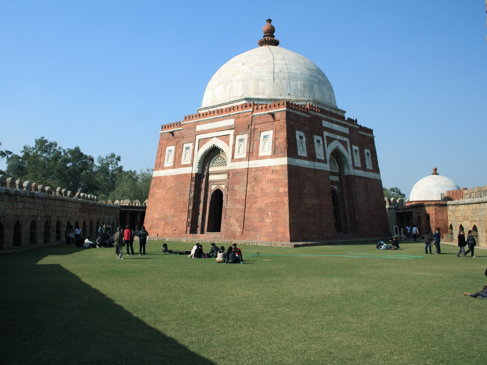
Before I left, I did cross the causeway across what used to be the moat cum water reservoir to the south of the Fort, leading to the Tomb of Ghiyas-ud-din Tughlaq. Historically, the tomb would have been in the middle of the lake caused by damming the low-lying area between the fort and the surrounding low hills. The tomb complex does contrast starkly against the austere barenness of the Fort. The tomb and enclosure are elegant, and well maintained. Here lie the remains of Ghiyas-ud-din Tughlaq, his wife, and his son and later Sultan, Muhammed bin Tughlaq. However, they weren't the first to arrive here. Cleverly integrated into the Tomb walls is the tomb of Zafar Khan, a trusted general of Ala-ud-din Khilji, credited with expanding and stabilizing the Khilji sultanate.
 |
| Entrance to Tomb of Ghiyas-ud-din Tughlaq |
 |
| Tomb of Ghiyas-ud-din Tughlaq (foreground) and Zafar Khan (small dome in background) |
 |
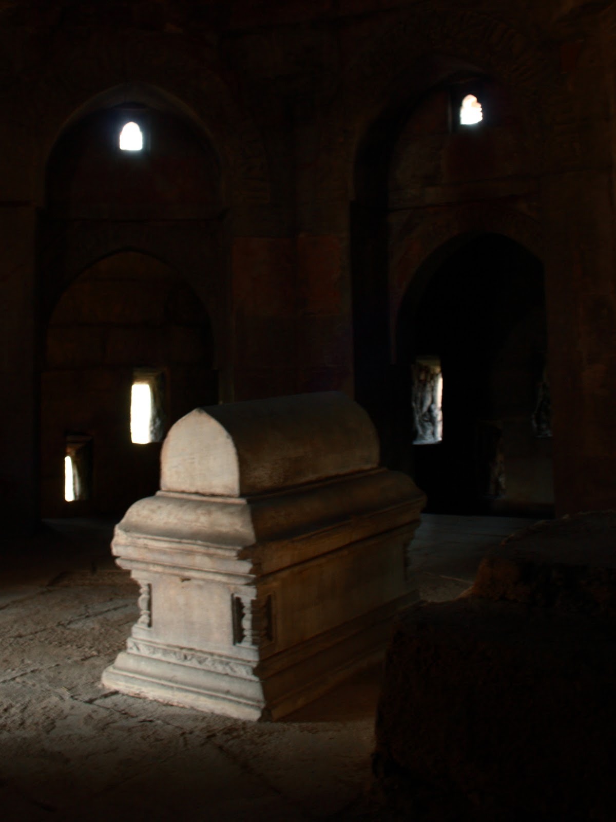
| Grave of Ghiyas-ud-din Tughlaq (his wife and son (Muhammad bin Tughlaq) lie on either side) |
 |
| Grave of Zafar Khan |
 |
| Pavillion with Lattice Windows |
 |
| Pointy Barbicans Surround the Tomb Complex |
As I left the tomb, I did glance at Adilabad Fort in the distance. Built by Mohammed bin Tughlaq, it served as his capital after Tughlaqabad Fort was abandoned in 1327, until his infamous shifting of the capital to Daulatabad and back to Delhi. This was additionally meant to protect the water reservoir and was close to sluice gates that fed water into the lake. Time limitations and fading light meant that I was going to have to leave it to another time.
Here is a map of the Tughlaqabad fort area mapped out.


No comments:
Post a Comment